The Australian bushfires continue to tear through the country, ravaging the land and animal populations.
At least 6.3 million hectares of land across the country has been burned since the start of the 2019 fire season.
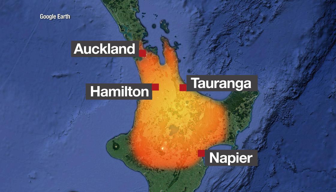
Newshub has produced five graphics to show the bushfire devastation overlayed with different locations.
Each graphic shows an impact area of 6.3 million hectares.
New Zealand

The total area for the bushfires over the North Island expands from Auckland in the north to Napier in the south, encompassing a total estimated population of 2.45 million. New Zealand's population is 4.79 million, based on the 2018 census.
The graphic shows major centres that would be impacted, including Auckland, Tauranga, Hamilton, Rotorua, Taupo, Napier and Hastings.
London and Southeast England

Across England, the bushfire-affected area would cover the entire southeast region from the coast. It would reach inland to Bristol in the west and Birmingham in the north, and would also encompass London.
Approximately 31.6 million people would be displaced across the country, according to a population count from the UK Office for National Statistics. The population of the UK is estimated to be 66.4 million.
Many historical cities and sites would also be impacted, including Oxford, Cambridge, Bath and Windsor.
Paris

The 2.14 million-populated city would be just one of many affected areas.
The graphic shows an area approximately 200 kilometres across in length. It almost reaches the English Channel from the centre of the country.
New York

Overlayed with the northeastern United States, the fire-affected region reaches from Philadelphia in the south up to Massachusetts in the north. This is a total length of approximately 385 kilometres.
New York City and Long Island are also shown in the affected area. Approximately 8.5 million and 7.9 million people alone respectively live here.
Tokyo

The fire would reach across Japan's mainland from Tokyo to Niigata, and almost reaches Kyoto in the southwest.
More than 31.4 million people are shown to be affected.
The land area of Japan is 37.8 million hectares, meaning almost one-fifth of the country is covered by the 6.3 million hectare-sized bushfire region.


